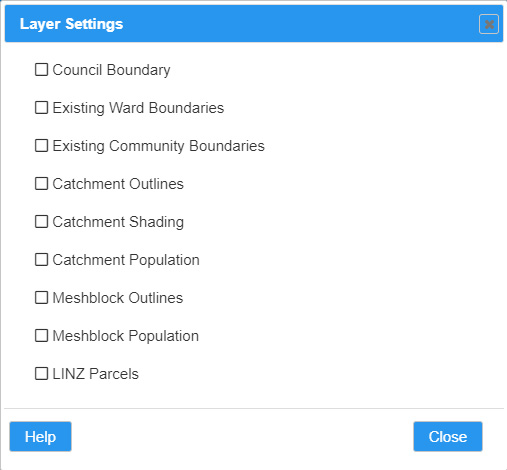
Council Boundary – Shows the extent of the existing Waikato District Council bounday. Sourced from Stats NZ Tatauranga Aotearoa.
Existing Ward Boundaries – Shows the extent of the existing Waikato District Council ward boundaries. Sourced from Stats NZ Tatauranga Aotearoa.
Existing Community Boundaries – Shows the extent of the existing Waikato District Council boundaries. Sourced from Stats NZ Tatauranga Aotearoa.
Catchment Outlines – Shows the extent catchment boundaries for the current model. Note these boundaries are only updated when the model is saved
Catchment Shading – Shows the model catchment areas using the colours defined in the model settings
Catchment Population – Shows the population of each catchment for the current model. Note this is only updated when the model is saved
Meshblock Outlines – Shows the outline of the meshblocks within Waikato District Council. Sourced from Stats NZ Tatauranga Aotearoa.
Meshblock Population – Shows the estimated population of the meshblocks within Waikato District Council. Sourced from Stats NZ Tatauranga Aotearoa. Note that the population values are only visible when the map is zoomed in – this is to avoid cluttering of the map.
LINZ Parcels – Shows the current LINZ parcel boundaries. Sourced from LINZ Data Service
Click Help to show this help page.
Click Close to close this dialog.